


|
News and Information
The incredible Caprivi Strip
| November 6, 2005 |
by Andreas Vogt
Travelling through Namibia is like travelling through several different historical epochs, continuously encountering different cultures and experiencing different types of climate and vegetation. The Caprivi Region in the extreme north east is entirely different to the rest of the country in all these respects, especially as regards its history.
Pointing like an outstretched index finger right into the heart of central Southern Africa, the Caprivi Strip is both a geographical and a historical curiosum. For its longest part, it measures a scant 32 km across before finally opening up into the shape of a rough triangle. Two rivers traverse the Strip, namely the Kavango in western Caprivi and the Kwando, both crossing into Botswana. The Linyanti and Chobe rivers constitute its southern border, while the River King of central southern Africa, the mighty Zambezi, forms its north-eastern border. At the easternmost border point Namibia links up with no less than three other national states – Zambia, Zimbabwe and Botswana. From this point on the map, the Indian Ocean is closer than the Atlantic Ocean along Namibia’s long shoreline.
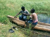
The climate in the Caprivi is truly tropical. It has Namibia’s highest rainfall average (up to 625 mm per year), causing regular floods in the Caprivi floodplains, which may be inundated for several months, threatening humans and livestock alike. When the floodplains dry up, they leave densely overgrown grasslands and sandy plains behind. The lush vegetation in the form of subtropical mopane woodlands and the north-eastern Kalahari woodlands are a rare sight for Namibians more used to tree-and-shrub savannahs and arid desert regions. As the animal wildlife abounds in a number of smaller national parks, and modern civilisation with thousands of ugly signboards hasn’t made its appearance yet, visitors experience an authentic Out-of-Africa feeling along the rivers of the Caprivi Region.
The sheer distances from any modern capital or major city are felt here, notably in the shape and style of traditional homes neatly built according to age-old traditions. They are usually rectangular and thatched with reed, while the walls consist of a sturdy timber frame intertwined with flexible branches and plastered with clay – an age-old house-building technique that is practical and eco-friendly. Often a cattle kraal consisting of a number of houses and a patch of millet that feeds the families of the mainly Silozi-speaking population of Caprivi is found in the direct vicinity of such a family homestead. The rural life here is tranquil. Were it not for the malarial mosquitoes, you could imagine having found the Garden of Eden itself.
Whence the region’s strange name? Referred to today as the Caprivi Region, it owes it name to the second Imperial Chancellor of the Second German Empire (1871–1919), Georg Leo Count von Caprivi de Caprera de Montecuccoli. This German general and politician succeeded the first Imperial Chancellor, Prince Otto von Bismarck (who was instrumental in the unification of Germany and establishment of the second German Empire under Emperor William I) in 1890 and held office until 1894. An agreement concerning the Caprivi Strip had already been concluded during a Portuguese-German treaty under von Bismarck in December 1886, whereby the northern boundary was defined as running in a straight line from Andara to the rapids at Katima Mulilo. At the time, the general area in and around today’s Eastern Caprivi still fell under British governance. It was thus under Count von Caprivi’s rule that the border issue was negotiated between Germany and Britain.
In the so-called Heligoland-Zanzibar Treaty, the African island of Zanzibar was exchanged for the small island of Heligoland in the North Sea off the coast of Germany, where the Germans had feared the British would establish a naval base right under their noses. One of the lesser issues addressed in this treaty were the borders of the Caprivi Strip, which the Germans were eyeing to gain access to Southern Africa’s most important water highway, the mighty Zambezi. They were oblivious of the Victoria Falls downstream, so shipping to the Indian Ocean was quite out of the question. It was in this treaty that the Strip was first declared as part of the German colony of German South West Africa. This treaty also fixed its width at 20 miles (32 km). The survey and marking of the Strip’s northern and southern boundaries were only finalised and fixed in the 1930s.
Given the remoteness of the Caprivi Region (the distance between Rundu and Katima Mulilo being some 500 km), access to this remote addendum to the German colony in those years was only possible by travelling from Windhoek to Swakopmund, then by boat to Cape Town, by train via South Africa and through North Western Rhodesia via Livingstone, and finally on the river to Sesheke and the ‘Imperial Residency’ of Schuckmannsburg. Although the borders of the colony had already been agreed upon in 1890, it was only in 1908 that the German colonial administration established a permanent residency for its representative, an officer of the Imperial Schutztruppe. The first one was Captain (Hauptmann) Kurt Streitwolf, as the first district commissioner of the Caprivizipfel (Zipfel being German for Strip). The small administrative headquarters were named after the German Governor at the time, Bruno von Schuckmann, who ruled from 1907 to 1910.
The small village of Schuckmannsburg is still difficult to access. Nowadays it has a clinic, a shop and some houses, both modern and traditional. The only visible reminder from the German period is a small building made from baked clay stones. When the Strip’s capital was moved to Katima Mulilo in 1937, several old clay brick buildings in Schuckmannsburg were demolished. The material was transported by river to Katima and used to build the new administrative building. Ten years later this building was demolished again and the bricks used for yet another building.
In the meantime, history has also left traces from more recent epochs. The old military base near Mpacha, Katima’s airport, is reminiscent of the bush war of the 1980s. New border posts have sprung up at Wenela and Ngoma, new bridges have been built across the Chobe River near the Ngoma border post and across the Zambezi River near the Wenela border post, welcoming visitors from abroad to the now independent Republic of Namibia. All the roads in the Caprivi, however, lead to its capital, Katima Mulilo, with its well-stocked shops, administrative buildings, small-scale industry and thriving tourism enterprises. |
Source: www. flamingo.mweb.com.na |
| http://flamingo.mweb.com.na/index.php?fArticleId=122 |
|
| Support Caprivi Freedom |
Fill out the form below to become a member of this site and receive our regular newsletter.
|

|