


|
News and Information
Navy releases tsunami images
| February 9, 2005 |
By Richard Black
BBC environment correspondent
The pictures will inform any new tsunami warning network (Image: Royal Navy UK)
More details
UK scientists have released images of the ocean floor near the epicentre of December's giant Asian earthquake.
They were obtained by the Royal Navy's hydrographic survey ship HMS Scott.
The three-dimensional pictures detail the deformed seabed 150km (94 miles) off the Sumatran coast, and reveal huge underwater landslides.
Researchers involved in the project believe the images may help in the design of the tsunami early warning system to be built in the region.
"There are features which we would think are something like the Grand Canyon would look," Tim Henstock, one of the scientists on board HMS Scott, told BBC News.
"You can see huge piles of mud maybe a few hundred metres thick; there's lots of evidence of activity at the subduction zone."
Water disturbance
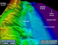
The images show clearly the boundary between the Indian and Burma tectonic plates - a region known as the Sunda Arc.
The flat Indian plate shows up in purple, which turns to blue as this portion of the Earth's oceanic crust disappears underneath the Burma micro-plate (part of the Eurasian plate).
This really was a grey area of seabed; we didn't have any information at all of any quality
Dr Russell Wynn, Southampton Oceanographic Centre
The forces created by this process have rumpled and buckled the surface rocks, whose folds show up in green and yellow.
Some images appear to show a large landslide some 100m high and two kilometres in length.
Scientists involved in this project believe the tsunami occurred when a portion of the Burma plate, which had been dragged down by the edge of the descending Indian plate, rebounded upwards, transmitting huge energy to the water above.
ASIAN QUAKE SURVEY
Click here for more
In pictures
It is the first time that this area of seabed has been mapped in detail, though project scientists believe that oil companies have conducted surveys here in the past.
Images returned so far reveal that while some portions of this subduction area were obviously involved in the Boxing Day earthquake, others were not.
Quality data
"The big question at the moment is why the earthquake occurred where it did, and all the aftershocks were then further to the north," Russell Wynn told the BBC News website.
A marine geologist at Southampton Oceanographic Centre, Dr Wynn is processing data sent back to the UK from HMS Scott by scientists on board, such as his Southampton colleague Tim Henstock.
HMS Scott (Royal Navy)
HMS Scott is scheduled to return to the UK in April
"The area to the south of the earthquake epicentre seems to be relatively unaffected," he said. "So one of the things this survey will try to understand is why that area was not affected, and is that an area where some time in the future there may be an earthquake?"
This information may prove vital in setting up an early-warning system.
There have recently been disputes between some of the governments involved, principally over where to site the system's co-ordinating centre; but from a scientific perspective, it is much more important to find the right sites for the sensors which will feed information to that centre.
"This really was a grey area of seabed; we didn't have any information at all of any quality," said Dr Wynn.
"So by doing this detailed map we will get an idea of where to site monitoring equipment on the seabed, and that monitoring equipment will then feed into early warning systems that hopefully some time in the future will contribute to saving lives."
Mission re-routed
For the crew of HMS Scott, this has been a unique mission. The ship's main role is to map areas of the sea floor which might have some military relevance.
The sonar array slung underneath its hull sends out pulses of sound waves, which reflect back from hard surfaces; these reflections can be analysed to produce 3D maps of the ocean floor.
HMS Scott was in the western portion of the Indian Ocean near the coast of Madagascar, sailing northwards, when the magnitude nine earthquake occurred.
Ocean floor off Sumatra (Royal Navy)
Tsunami origin: The quake shook the rocks which disturbed the water column above
The UK's Ministry of Defence decided to re-route the vessel eastwards. It docked in Singapore in late January to take on supplies and civilian scientists, from the British Geological Survey and Southampton Oceanography Centre.
After receiving permission from the Indonesian government, HMS Scott then sailed for the earthquake epicentre.
Currently in charge is Lieutenant-Commander Gary Brooks, the ship's Executive Officer.
He told BBC News that his crew knows relatively little about the impacts of the tsunami.
"We've been quite shielded from all this," he said. "We sailed on 27 December, when little news had broken; and being at sea, we have a very closeted life, away from what goes on in the real world, and we haven't seen any of the shocking images.
"We are working some considerable way off the coast, and so we haven't physically seen any devastation or anything else; we're here, we know why we're here, we know what's happened, we know what we're trying to achieve and what we're doing for the future, but we're unaware really of the devastation and the problems that the world has gone through."
HMS Scott is scheduled to return to the UK in April. |
Source: www.bbc.com |
| http://news.bbc.co.uk/2/hi/science/nature/4247409.stm |
|
| Support Caprivi Freedom |
Fill out the form below to become a member of this site and receive our regular newsletter.
|

|